Localisation
Nantes, France
The aim of the workshop is to bring these issues within the International Ambiances Network’s debate. The workshop will gather two teams of the Network, who will share their experiences within the French and Italian contexts. Eleven short presentations will be given by the researchers of both teams in three sessions regarding:
- Solar, luminous, microclimatic and visual simulation of urban environments
- Virtual reality and urban ambiances
- Case studies of simulation for urban design
A large place will be given to open discussions for further collaborations.
Support
Pascal JOANNE
Architect, PhD, Senior lecturer, Graduate School of Architecture of Nantes, CERMA UMR CNRS/MCC/ECN 1563
Pascal Joanne, Architect, PhD in Applied Sciences, is Senior lecturer at the Graduate School of Architecture of Nantes. He works on the characterization and the restoration of the conditions of comfort in buildings or remarkable sites, and more particularly on the medieval cistercian architectural spaces. Since 2008, he is Director of the CERMA Laboratory, and since 2010, he is the manager of a master’s degree on « Ambiances and urban forms ».
Thomas LEDUC
PhD, Researcher, Graduate School of Architecture of Nantes, CERMA UMR CNRS/MCC/ECN 1563
Thomas LEDUC is graduated in Mathematical engineering. He obtained a PhD in Computer Science from Paris VI University. He is currently a tenured CNRS Research Engineer, in the CERMA Laboratory from the Nantes Graduate School of Architecture. His research activities focus on the urban morphology characterization using the geographic information science and technology. He is involved in several projects that aim to describe open spaces morphology using visibility-based methods. He organized and chaired the final conference of the European Cost action TU0801 entitled ‘3u3d-2012: Usage, Usability, and Utility of 3D City Models’ (Nantes, France, Oct. 2012).
Laurent LESCOP
Architect, PhD, Senior lecturer, Graduate School of Architecture of Nantes, GERSA
Guillaume MOREAU
PhD, HDR, Professor, Ecole Centrale Nantes, CERMA UMR CNRS/MCC/ECN 1563
Guillaume Moreau obtained an engineering Degree in 1995, a PhD in Computer Science from University of Rennes I in 1998. He was accredited as a PhD advisor in 2009. He is currently professor in Computer Science at Ecole Centrale de Nantes where he is director of the Computer Science and Mathematics Department. His research takes place at Cerma lab, he focuses on Virtual and Augmented Reality and he is committed at studying the link between information systems and digital images with the help of Virtual and Augmented Reality.
Eugenio MORELLO
Architect, PhD, Assistant Professor, Politecnico di Milano, Department of Architecture and Planning, Laboratorio di Simulazione Urbana Fausto Curti
An architect by education, Eugenio Morello is Assistant Professor in Urban Design at the Politecnico di Milano (POLIMI) since 2010. He is also research scientist at the Laboratorio di Simulazione Urbana Fausto Curti, Department of Architecture and Urban Studies (DAStU). His research interest is urban environmental quality and urban morphology. He works in particular with digital simulations and prediction models for the integration of environmental aspects and energy systems within the design of sustainable neighborhoods. He was previously a Roberto Rocca postdoctoral fellow at the Human Space Lab, POLIMI (2009) and at the SENSEable City Lab, MIT (2008). He was also adjunct professor at POLIMI since 2006, where he taught urban design. He holds a Ph.D. in environmental design and building technology from POLIMI (2006).
Marjorie MUSY
PhD, HDR, Researcher, Graduate School of Architecture of Nantes, CERMA UMR CNRS/MCC/ECN 1563 – IRSTV
Marjorie Musy is researcher at CERMA laboratory and joint manager of IRSTV. Her research activity are: urban microclimate modeling, building energy consumption, natural ventilation, impacts of urban vegetation (VegDUD project), impacts of urban form and matérials.
Barbara PIGA
Architect, PhD, Adjunct Professor, Politecnico di Milano, Department of Architecture and Planning, Laboratorio di Simulazione Urbana Fausto Curti
An Architect by education, Barbara E.A. Piga is Adjunct Professor in Urban Design at the Politecnico di Milano(POLIMI) since 2011, where she is also research fellow (since 2010). She is research scientist at the Laboratorio di Simulazione Urbana “Fausto Curti” (DAStU) since its foundation in 2007 and holds a Ph.D. in Urban Planning from POLIMI (2010). Her research interest is urban design and perceptual simulation. She works in particular with dynamic simulations of the urban environment as a design and evaluation tool.
Valerio SIGNORELLI
Architect, PhD, Researcher, Politecnico di Milano, Department of Architecture and Planning, Laboratorio di Simulazione Urbana Fausto Curti
An Architect by education, Valerio Signorelli holds a Ph.D. in Territorial Design and Goverment from the Department of Architecture and Urban Studies (DAStU) at the Politecnico di Milano. He is a research scientist at the Laboratorio di Simulazione Urbana “Fausto Curti” (DAStU) since 2007. His research interest focuses on urban design, sensory urbanism and digital simulation tools. He works on the role of the various sensory stimuli (mainly auditory stimuli) for defining well-being in urban open spaces, and the employ of ‘game engine technology’ as design, evaluation and communication tools.
Daniel SIRET
Architect, PhD, HDR, Researcher, Graduate School of Architecture of Nantes, CERMA UMR CNRS/MCC/ECN 1563
Daniel Siret is an architect with a PhD in Applied Sciences from the University of Nantes (1997) and has been accredited to direct research since 2010. In 2001, he became a tenured researcher at the Graduate School of Architecture of Nantes (CERMA Laboratory, UMR CNRS 1563). His work deals with the ways in which sensorial dimensions are taken into account in conceptions of the built environment, especially with regard to the architectural and urban expression of solar radiation. He was in 2012 a visiting scholar at the Canadian Centre for Architecture in Montreal. With Jean-Paul Thibaud, he is presently co-director of the International Ambiances Network.
Vincent TOURRE
PhD, Associate Professor, Ecole Centrale Nantes, CERMA UMR CNRS/MCC/ECN 1563
Vincent Tourre is an Associate Professor since 2009 at the CERMA, which is a joint research team of the CNRS (UMR 1563), the Graduate School of Architecture of Nantes and Ecole Centrale de Nantes. He holds a master thesis in computer science and a PhD thesis in architecture. His research interests concern the use of natural lighting during the early stages of architectural design, and the modelling and visualisation of urban data dedicated to urban planning and GIS applications.
Toinon VIGIER
PhD Candidate, CERMA UMR CNRS/MCC/ECN 1563
Toinon Vigier is a graduate computer engineer from Ecole Centrale de Nantes, France. After completing a master degree’s in sciences and techniques in urban environment (2011), she is a PhD candidate at CERMA laboratory on the theme of virtual ambiances. More precisely, she works on the use of virtual reality to propose a perceptual and sensitive approach of urban environments.
Thursday June 13th
17:15 | 17:45 – Presentation of the Naexus project, L. LESCOP
Friday June 14th
10:20 | 10:40 – Urban morphometrics: investigating the environmental performance of the urban form, E. MORELLO
Solar, luminous, microclimatic and visual simulation of urban environments
Solar and luminous simulation with Solene software
Vincent TOURRE
Abstract
– Presentation of solar and luminous simulation in Solene software
– Solar Lighting: Aid the design process in the definition of artistic installation
– Inverse Lighting: Aid the design process in a constrained project with complex lighting intentions
– Enrichment of the 3DCM: city scale indicators and merging with others indicators, and visualisation of data
Urban microclimatic simulation
Marjorie MUSY
Abstract — In the current context where the consequences of urban development must be fully understood, knowledge of urban physical phenomena is a key factor in the pursuit of sustainable cities. For this purpose, modelling offers a decision-making support system for establishing urban environmental policies. Enhanced knowledge of urban microclimates is required to: control the urban heat island effect; conduct air quality and amenity studies; manage the risks of flooding and water pollution; and monitor energy consumption. It is then necessary to study the interaction between physical phenomena at various urban scales. The presentation will provide guidance so as to better understand: urban climate modelling and the modelling of urban energy consumption by buildings in an urban context. Emphasis is placed on applications that focus on an evaluation of urban forms and climate adaptation and/or mitigation techniques.
Visibility and predictability: towards cartography of the hidden part of landscape
Thomas LEDUC
Abstract — The relationship between visual perception and spatial organization is still, nowadays, a key question to anticipate the human behavior and to help improve the quality of life. Urban planning and urban design approaches are focused on buildings and several methods have been developed to visualize the built and non-built space. Nevertheless, in most of them, the main focus is often the built space rather than the voids between the buildings.
According to permeability theory, surroundings’ configuration and, more precisely, the existence of occlusions in our enclosure may invite us to explore our environment. This presentation aims to analyze, in a systematic and reproducible way, the ratio of mystery in one’s surrounding visualscape. To assess this property in each place, we recall three indicators relative to the boundary predictability (entropy), the weight of visual heap (drift), and the occlusions ratio (occlusivity). We also introduce a fourth indicator which weights each occlusion (anticipation). At last, we refer to some convex partition technics of urban open spaces.
The anticipation indice corresponds to the averaged ratio of the background distance divided by the foreground distances, times occlusion length. Two extreme urban configurations regarding anticipation (credits: Thomas Leduc).
Bird eye view of an isovist in the urban fabric. The viewpoint position is represented by a black focal point. A contour sampling based on 32 regularly-spaced angular abscissa is plotted (credits: Thomas Leduc).
Representations of the predictability, the drift, the occlusivity, and the anticipation in each point of a given urban fabric in Nantes city, France (credits: Thomas Leduc).
Urban morphometrics: investigating the environmental performance of the urban form
Eugenio MORELLO
Abstract — Policy makers today show an increasing interest in cities as the correct level of investigation and the main drivers toward achieving effective environmental sustainability. For example, work on future scenarios for cities is not concerned with social and behavioral policies alone but also the spatial configuration of our built environment. In fact, the city is intended here as a physical and spatial entity, the result of planning strategies, whereby the construction of the space plays a fundamental role toward the improvement of the Urban Environmental Quality (UEQ).
A number of tools based on the image processing of digital urban models were developed for supporting sustainable urban design (analysis, design and evaluation) and are here presented. The final aim of this research work is to deliver a comprehensive spatial planning support system (SPSS) which includes energy, environmental and morphological aspects of the built environment and provides the assessment of alternative sustainability scenarios depending on land use and available local resources.
For instance, a first set of tools implemented on energy-conscious urban planning and design principles, offers the opportunity to architects and planners to gain new relevance in the decision-making process. In fact, recognizing different peculiarities of urban patterns can be deployed in order to assess future energy scenarios: firstly, urban patterns can be interpreted as energy basins with different opportunities in terms of conservation, production and storage of energy on-site; secondly, urban patterns are also ecological systems and can be characterized by different levels of biodiversity, soil permeability and anthropogenic pressure, just to mention some relevant aspects.
A second set of tools based on algorithmic design explores the feedback of energy and environmental aspects in defining new generative rules for both architectural composition and urban design: hence, energy and environmental quality were investigated as form-givers of the built environment and presented here through a series of case-study applications.
Virtual reality and urban ambiances
Virtual reality for urban design
Guillaume MOREAU
Abstract — As far as Virtual Reality is concerned, Architectural and urban projects propose exciting challenges with respect to standard manufactured projects for which is has become a very common tool. Among those are the need for subjective assessment of the project because of its audience, its lifetime and most notably the fact that there will probably be only a single instance which hinders the construction of physical prototypes. Project assessment requires to be able to compare perception in real and virtual environments in order to be able determine the bias of Virtual Reality studies. In this talk, we will show how we rely on real evaluation schemes to build a comparison between a real built project and an « homologous » one in a virtual environment. Examples on daylighting ambiances in an urban environment and wind turbine impact assessment will be given.
Two other main issues must also be addressed for those studies, we will simply demonstrate their importance in this talk:
Project scale: here we have to face the scale difference between the project and the immersive room that is used for experiments, hence raising the question of the observer’s motion in the virtual world. To this stage, Augmented Reality can also be an asset.
The environment: an urban project cannot be disconnected from its environment, i.e. we need to find how such an environment can be built, maintained and rendered at various scales and levels of details.
Urban levels of detail
Experience of comparative shapes between real and virtual environments
Perception of wind turbines (real)
Perception of luminous atmospheres
Microclimatic suggestion in virtual reality
Toinon VIGIER
Abstract — Thanks to immersion and interaction, virtual reality is a good tool to assess urban environments. Allowing users to freely navigate in the virtual environment, virtual reality permits to take into account the influence of dynamic elements and the observers’ actions in the perception of urban spaces. However, previous works have shown that virtual assessments of urban projects are mainly based on visual experience. Thus, multisensory perception of the actual environment is biased. In addition, virtual urban environments are often presented in ideal conditions: sunny day, lush vegetation, appealing characters, little traffic, perfectly cleanliness of sites, and no wear in buildings or urban furniture.
In order to tackle these issues, we have chosen to focus on climatic ambiances, which are dynamic and multisensory. Moreover, some studies have shown the importance of these factors in the appropriation of an urban space whereas they are very seldom integrated in virtual evaluations. Our talk will first present a new methodology to suggest urban climatic ambiances in virtual environments which respects the following points: understanding and perception of climatic ambiances by non-experts, sensitive evaluation of the urban space, presence in the virtual scene and perceptual fidelity of the virtual environment. Then the results of a perceptual experiment conducted on 42 participants will be presented and discussed.
The perceptual experiment
The “standard” scene of virtual urban environments
A scene evaluated during the perceptual experiment
A scene evaluated during the perceptual experiment
A scene evaluated during the perceptual experiment
Interactive urban environments
Valerio SIGNORELLI
Abstract — Cartographic maps and, generally, bi-dimensional representations, are the tools used by planner and architects to show, to analyze and also to simulate the urban environment both as it is, and in its future conditions. However, for these undeniable useful products some limits that reduce their communication capability can be highlighted. First of all these ‘tools’ are mainly statics and bi-dimensional, while the urban environment is highly dynamic and characterized by the third dimension. Moreover, these representations are often realized using drawing conventions that are not easily comprehensible for lay people. Another issue is that the majority of these products are focused on a visual translation also for sensory stimuli that are not perceived with sight.
Along the last decades the informatics technology has been proved in order to provide an effective communication capability, especially towards no-experts users. Nowadays 3D models are widely used in the architectural design process (not only for a communication purpose) nevertheless these products has been less employed in urban practices and, when it happens, the results are often static representations and they are mainly used for advertising purposes.
In the last few year new interactive software, employed to represent virtual environments, have been developed by various disciplines. Among these disciplines game design studies are particularly interesting for urban design purposes. In this field a particular kind of software is very relevant: the game engine, a tool developed at the beginning of the 90’s to produce videogames.
The urban environment can be virtually represented using this tool and can be enriched, for example, with auditory stimuli and dynamic components (like the traffic flow or the rhythm of day and night). Moreover, with this tools it is possible to provide a product that can be interactively navigated by the user. It can allow to visualize, in real time, the various design proposals from points of view not previously given by the designer. There are various fields in which these products may be employed, from the educational to the professional one, as an effective support for design and evaluation.
Piazza Leonardo
Unity
Unity
The Naexus project
Laurent LESCOP
Abstract — Le Naexus est un dispositif immersif conçu par les écoles d’architecture de Nantes et Dessau en Allemagne. L’ensemble se présente comme une sphère ajourée en bois, abritant un écran panoramique cylindrique de 12m de long de 2m de haut. Quatre vidéoprojecteurs synchronisés construisent une image s’enroulant à 220° autour des utilisateurs. L’ensemble est piloté par un système Windows classique ouvrant la diffusion à tous types de contenus. Une douzaine de personnes peuvent se tenir au sein de l’espace de projection.
Le Naexus par sa conception interroge de nombreux domaines normalement attachés à celui de la réalité virtuelle. Sa conception sous forme de lanterne magique, pose une première question de rapport intérieur / extérieur. Posé au sein d’un espace connoté, le Naexus propose un système d’amorce différent de celui des dispositifs équivalent. Plus qu’un lieu de projection, il est lieu de rassemblement, de partage et même d’abri. Les visuels proposés peuvent s’entrevoir, émerger par le son, produire des effets de curiosité ou de voyeurisme, ou bien encore, servir de refuge, de salon, de cachette.
Le Naexus offre donc un terrain expérimentale tout à fait stimulant pour ce qui concerne la mise en cohérence d’un dispositif, du mode de projection et du contenu proposé. De nombreuses expérimentations sont menées interrogeant séparément ou simultanément chacun de ces points. Le Naexus irrigue également la problématique des ambiances en ce qu’il manipule des états d’ambiance, des effets, déploie largement les notions de synesthésie et d’amorce.
Simulation and urban design, case studies
Nantes Tripode project
P. JOANNE
Abstract — The objective of this work was to assess the design of the architect with a « bioclimatic » approach. Having selected relevant environmental indicators, solar and aerodynamic simulations where realized to make sure that the architectural choices (volumetries, orientations, openings, compactness, etc.) meet the needs in energy, while insuring the comfort of the users and the residents. The approach showed the necessity of building an adapted model (simple but not approximate). The results showed some penalizing situations, mainly in terms of sunshine duration, as well as risks of overheating.
Primary design of the project
General geometry with the meshing
Sky access analysis
Analysis of the visibility
Lyon Confluence urban project
Marjorie MUSY
Simulation for evaluation: The transformation of the Garibaldi – Repubblica district in Milan
Barbara PIGA
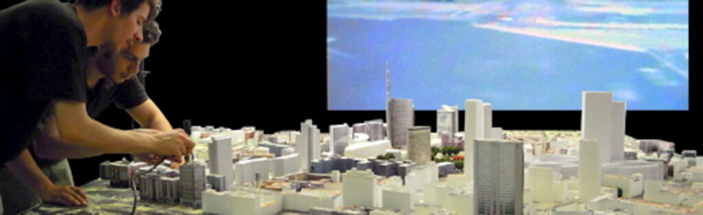
Abstract — Visual simulations are largely used to describe urban projects, but often these descriptions are disattended by the constructions. This is mainly due to the fact that these images are created by the developer in order to promote their projects, and not as analytical tools. For instance, renders often present pleasant alluring atmosphere but rarely describe the change inducted in the actual context. This kind of medium can be misleading, but, if carried out with a scientific method, it can be an effective and reliable support for evaluation; in fact, simulations can be used to accurately anticipate the visual perception induced by urban transformations, and in so doing they can contribute to demonstrate their validity from an experiential point of view. This is one of the main focuses of our research laboratory.
The Garibaldi-Repubblica project in Milan was used to test potentialities and weaknesses of the approach, and to investigate the usefulness of perceptual simulation for design and evaluation. Different typologies of mediums were used to study the cumulative outputs of the project at the local and the urban scale. Since the way we perceive reality is in time and space, a specific focus is devoted to dynamic simulation of the urban environment. The study was conducted using both physical and digital models, and interactive simulations were favored. Some simulation tools were developed ad hoc and will be presented.
Digital model
Endoscopy